Page 1 of 4

This might be a good place for Louisville boulderers

Posted: Mon Mar 01, 2010 9:58 pm
by Redpoint
I found a cool area not too far from Louisville that looks promising. The park is called Knobs State Forest http://tinyurl.com/ygj3flz , and I haven't seen any rule that says no climbing.

Some guys from Geocaching.com found a canyon there, and yesterday I went to go check it out. What we found was 2 free standing sandstone boulders, one was small and the large one was really wide(a lot wider than any of my pictures, maybe twice as wide) and decently tall. I found a hard problem on both of them and they were hard enough that I didn't want to finish them without a bouldering pad. I also found a simple one on the large boulder (I'm climbing it in the picture). The large boulder looks like it might have awesome potential for a few more extremely hard lines, but they would probably have to be cleaned.

There is also a large sandstone wall there that looks like it might have a bunch of problems on it, but it was all wet and so I didn't climb it, and I didn't even look for lines on it. I did notice plenty of slopers on it though.

Here is a collage of the canyon's boulders: http://img706.imageshack.us/img706/1861/knobsj.jpg

I didn't get any pictures of the wall, but I'm hanging from the small boulder, and the rest of the pictures are of the large boulder.

Here is the GPS coordinates to the spot: N 37° 52.396 W 085° 41.138

Here is the geocache page of the canyon on geocaching.com: http://www.geocaching.com/seek/cache_de ... 9f7af6c7f6

There is a better place to park than the normal Knobs State Forest parking lot: driving down Preston highway heading south, go past the sign that says "Knobs State Forest", and drive for a little while longer, and then turn left on Wilson Creek Road. Drive for a while and eventually you will see a small gravel parking lot on your left, it slopes up hill and sort of looks like a driveway. Here is GPS coordinates to the parking lot: N 37° 52.236 W 085° 41.996

It's a 1 mile hike to the canyon, and there is plenty of small hills to tackle, and one big one.

If you go out there and check it out

Please make a post in this topic about your thoughts on the place.

NOTE: There might be more boulders in the canyon. We walked in one direction(south) to where there is supposed to be a swimming hole (we think we found it but it was shallow), and we b-lined it back to the parking lot, and so the other side of the canyon is still a mystery to me. I doubt anything is there though, because the canyon just looked like it was getting wider and less steep in that direction(north).

Posted: Mon Mar 15, 2010 2:19 pm
by rockclimbingmao
Good find, but since this is WMA there is no climbng. If you google rock climbing at Knobs State Forest KY this pops up...

KY: Kentucky Dept Fish and Wildlife - Public Hunting guide
There are no ponds or lakes on the Knobs State Forest & WMA so fishing ..... No ATV's, camping, horseback riding, or rock climbing is allowed on the WMA. ...

Posted: Mon Mar 15, 2010 4:01 pm
by jrathfon
is the WMA surrounding land? according to google maps, that "canyon" is out of the state forest. good find, leads me to wonder if there is other sandstone in them thar hills down there.

google maps

can't get this damn link to work... just copy and paste the coord's into google maps.

Posted: Wed Mar 17, 2010 3:54 am
by Redpoint
Ya Google maps is out of date, they bought a bunch more land, and this canyon is on it. Just compare the park boundaries on Google maps to this map: http://forestry.ky.gov/Kentuckysstatefo ... tances.pdf and you will see that I'm right. The park goes all the way to Wilson Creek Road now where there is a parking lot. This is where you should park if you are going to visit the canyon.


I have searched this website thoroughly, and I just can't find a no climbing rule:
http://forestry.ky.gov/Kentuckysstatefo ... tArea.aspx


This part of their website http://www.forestry.ky.gov/programs/stateforest/ says:

"The state forests are open to the public for hiking, wildlife viewing, hunting, fishing (if available) and other activities. Horseback riding is allowable on all state forests with the exception of Knobs, Marrowbone and Rolleigh Peterson state forests. Off-road vehicle use, including ATVs, is prohibited on all state forest land. Please visit each state forest's Web page for additional information."

By other activities I can only assume they are talking about climbing :)


rockclimbingmao in a message told me he thought there was no climbing allowed there because "if you google "climbing at Knobs state forest KY" it comes up on the search bar.. no climbing."

I looked further in to the matter, and that rule only applies to 67. Ashland WMA: http://www.kdfwr.state.ky.us/kfwis/wmaguide.asp


jrathfon, there is some climbing on those hills, or at least one that I know of:

Park in the parking lot where you have to drive through the shallow creek, which is where the orange trail starts. stay on the orange trail for 2.4 miles and it will take you to the top of a huge knob, and it's a tuff hike. The scenery up there was killing anything at Bernheim. My brother read that the knobs there are taller than Bernheims. Once you hike up this hill it's 360 degrees of amazing scenery. If you keep walking you come to a sandstone bluff that makes you think you are in the Red River Gorge.

I found two boulder problems on this bluff, one is an easy V0-.

The other one is so hard I would of had to have climbing shoes, a bouldering pad, and a spotter to send it. It's a roof problem, and that's one reason why it's so hard. It's an amazing problem with a few tricky, slopey parts after you handle a big handhold that doesn't look too solid. The slopey top out looked hard but doable. The landing was pretty flat with a hill behind that, and the landing zone is full of flat rocks laying on the ground.

The scenery at the bluff is unobstructed and really amazing. The only bad part of the trip is when the trail, well it's more like a road, gets obstructed by trees and it's a tiny bit tricky to find the next orange markers and to stay on course, but it wasn't that bad.

WARNING: The picture below has some beta for the V0-.

The scenery shot was taken a little while after fall. The panorama was put together using Photoshop (Photoshop CS4 has a new tool that automatically makes panoramas for you and blends the sky perfectly. That wasn't used to make this one, but I just thought maybe some people would like to know that).

Ok here are the pics:

http://i43.tinypic.com/1z1ry8o.jpg

P.S. Don't forget to post your trip reports in this subject if you go there to climb or check out the climbing, please..

Re: This might be a good place for Louisville boulderers

Posted: Tue Nov 08, 2011 10:05 am
by Redpoint
I finally went to Knobs State Forest to check out the bouldering potential. It's not great, but at least I was able to make up some problems: http://vimeo.com/31777191

Re: This might be a good place for Louisville boulderers

Posted: Wed Oct 17, 2012 2:13 am
by Redpoint
I got two updates:

1:

I worked on my project at Knobs that was at the end of the Orange trail: http://vimeo.com/41898668

The Orange trail is finally cleaned up, but the ticks were heinous.

I ended up tweaking my ankle for 6 months because of that fall. For a while I felt I should of had a spotter instead of a videographer, but I'm pretty sure I would have sent my spotter down the hill with me.


2:

I went to Bernheim to look for bouldering. The first bouldering I found was on Rock Run Loop. Just go right at the fork, and within a few minutes you will see a limestone feature on your right, right next to the trail. There is a cool roof with giant upside down knobs. I made up two problems there; one in the center that starts on a stalactite like jug, and one on the right that starts on a ledge under the overhang. The left side had too many dirty holds. Here is a topo:
Image

After that I had a plan to scope out Wild Cat Hollow. I was biking up Forest Hill Drive and saw some sandstone boulders down there last week.

I parked at the Jackson Yoe Loop and hiked the whole hollow. About half way up I saw 3 short boulders. The one closer to the creek was just some 45 degree kiddy slab. I tried to make up a contrived traverse on the higher left boulder, but it was crappy. I made up a V- on the one to the right of it on an arete.

I continued my hike east, and came up on a sandstone cliff that was about 15 feet high. There was a nice handcrack there. It got a little overhung at the end. It needed to be cleaned though; it had a couple small loose blocks, one part had dirt that could be cleaned out that was about 1 1/2 inches deep in the crack, and then there were some spider webs. It was really dry though. It's a little larger than your fingers. I don't care for cracks so I left it alone.

15 feet further I found an amazing line, it's just around the corner from the crack and finishes on the arete.
After a handful of attempts I sent it. I wrote V5 in sticks under the rockshelter with an arrow pointing to the start holds. I think I'll name it Wildcat. It starts with your right hand on a crimp rail, your left hand on the same crimp rail, but on more of a slanted crimp, and your feet on a chossy ledge under the rock shelter. The boulder right next to the chossy ledge is obviously out. Try not to dab on it if your feet cut, I did once. Just so you don't think the problem has no feet, my tip is heal-hook. The landing isn't great, but it's not horrific either. You can see I stacked some rocks to make it better. I would protect the rock(not the big one next to the chossy ledge but a smaller one) just above my rock stacks too. I was able to protect the problem with just a 4X3 Mad Rock pad, but missing the first move would have been problematic with such a small pad.

-------------------------------------
WARNING BETA:
I will now give step by step beta for the problem. Start as I said above. Throw your left hand up to a much better rail, heal-hook with your right in the feature that looks like it's designed just for that. Bring your right hand up for the match. Slide your left hand along the rail until you hit the bomber spot. Bring your right heal on to the starting holds. Make a long move out left to avoid the slopey part of the rail. Bring your right hand to the good bomber spot. Move your left hand further on to a crimp***. I then went from a right heal-hook to a right toe-hook. Bump your left up to the flat jug. Find the crescent shaped left foot under the overhang. Finally you will get matched on a higher really good rail. The crux for me felt like this next move: bring your left foot up to the crimp***, stand up on it, and you're now topped out. I used the tree to get back down faster. NOTE: it goes something like that.
-------------------------------------

Further I found an ok slab problem. It was much better when I avoided this loose block, but I went ahead and cleaned it. When I did it went from a V1 to a V-. Just avoid the dirty jug if you want a good problem. There is a hidden sidepull crimp just under the dirty jug to the right of it.

Google maps: http://maps.google.com/maps?q=37.9031,- ... 1&t=p&z=15

Here is the GPS coordinates:
Latitude Longitude
N 37 54.186 W 85 38.082

NOTE: The sandstone wall is just a little east of that. Those 3 boulders are right next to a big feeder creek that's full of small sandstone rocks.


Best Approach:

For the easiest access I would recommend parking at the Canopy Tree Walk, walk down hill on Forest Hill Drive(go right at the fork), and look for a feeder creek on your left that goes down the steep hill. There should be a limestone man-made wall on the feeder close to the road. The crack and good problem are West(turn right) of the feeder. The hike should be about 0.4 miles(about 10 minutes). Here is a map I made: Image

Re: This might be a good place for Louisville boulderers

Posted: Thu Oct 25, 2012 4:42 am
by Redpoint
I went to knobs the other day and came up with 5 new problems, all low-balls.

To the far left on the big boulderer there is a very overhung cave like feature. You can start on the right and climb left, upside down, then top out. I was able to protect it with pads, but it was really hard not to dab. (V0)

At the same spot you can start in the middle and grab some cool hard to find crimps on top for the top out. It was too tight of a squeeze to do with a pad, but I got someone to hold it a couple of feet off the ground to protect my head. (V2)

On the smaller boulder I found a sweet problem. Stand start under the overhang, left hand goes on a crescent sidepull, right hand on a crimp sidepull rail, and left foot is on the sloping foot with all of the shoe rubber on it. Walk your feet up on great footholds, then make a really big move strait up, match, traverse right, and top out. (V4)

In between the main two boulders there are some more boulders. I saw what looked like it would be a good lip traverse, and to my surprise the moss on the lip was cleaned. I think someone already brushed it for me. I started on the right and traversed all the way left, then topped out. It had a balancy start. (V1)

I explored around there some more and found a couple of problems on the backside. One was real easy, and the other one had a hard top-out. It was getting dark and I had to go before I got a real chance to try it.


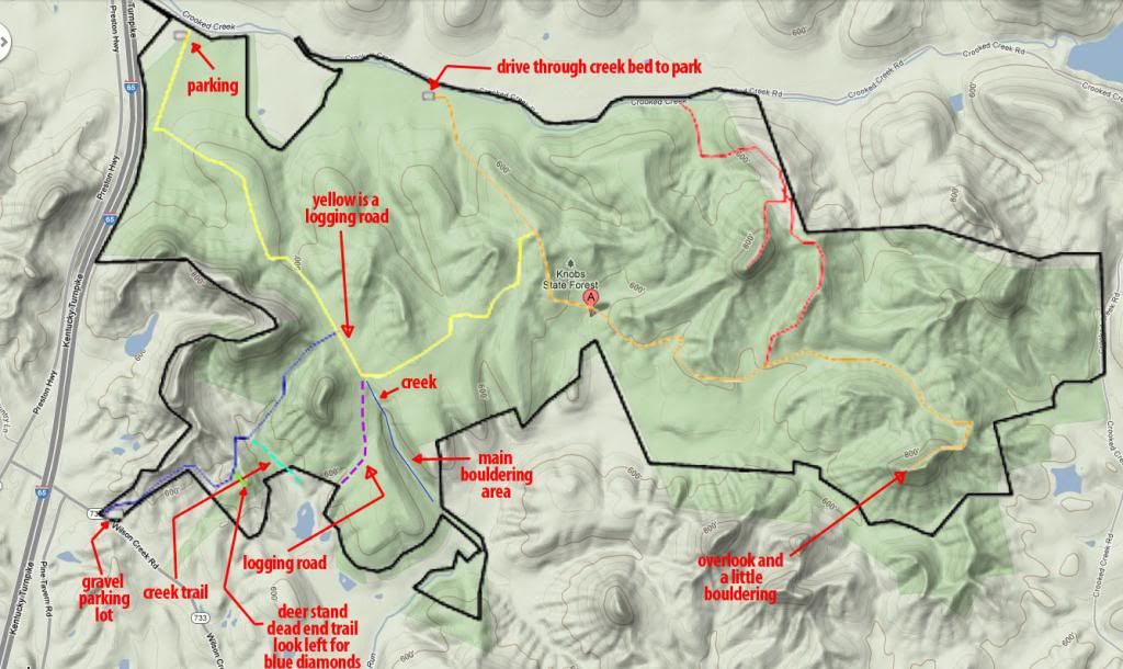
I made a nice map:
Image


Directions:

From Louisville on i65, drive 12.6 miles south of Gene Snyder taking Exit 112.

Turn right on Clermont Road and go 0.6 miles.

Turn left on Preston Highway and go 3.8 miles.

Ignore the Knobs State forest sign!!!

Turn left on Wilson Creek road and go 0.3 miles.

Turn left on to the gravel road with the gravel parking lot.

Hike the blue trail (about 1 mile).

NOTE: About 0.4 miles in to the hike, you get to the top of a hill. It looks like you are supposed to go down a steep hill and then up a steep one, but it's a dead end (deer stand). There is a fork, be looking left for the blue diamonds.

NOTE: Near the end of the blue trail, you come to a bunch of small trees and it's hard to find your way. Just keep going the direction you were going (north east) until you hit the yellow trail, which is right next to that spot.

The yellow trail is a logging road, take a right when you get to it.

You will come to a fork, the yellow trail makes a hard left, keep going strait.

You should be able to see the beginning of the creek at this fork. This is the creek with the bouldering.

As you walk down the logging trail the creek will be on your left. I usually walk about 0.2 miles, then bushwack left down in to the hollow.

You can see the boulders/cliff from the creek, so you can't miss it.

Re: This might be a good place for Louisville boulderers

Posted: Thu Oct 25, 2012 10:19 am
by tbwilsonky
classic

Re: This might be a good place for Louisville boulderers

Posted: Thu Oct 25, 2012 10:56 am
by kafish2
Videos of the new stuff coming?

Re:

Posted: Thu Oct 25, 2012 12:41 pm
by possum2082
rockclimbingmao wrote:Good find, but since this is WMA there is no climbng.

good thing this is bouldering, then. ;)