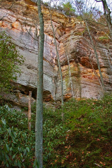
You really think it's only 1000' from Jewel Pinnacle? That's pretty close, like barely 5 minutes of shwacking.
Anyway, there are cool unknown walls all over the region, some climbed, some not. I have been consistently amazed by the quantity and quality of rock still out there to be both discovered and rediscovered. It's kind of hilarious that 95% of the climbing "crowd" these days basically never ventures out of the southern region and Muir Valley... Spaas Creek alone has another generation's worth of rock. All the better for us depraved choss hunters!!
A Not So First Ascent - What did we climb?
Re: A Not So First Ascent - What did we climb?
They have the wall pointed out exactly where it should be on the map. It's not Chimney Top and it is not Pinch-Em Tight. It is definitely un-named. It is smack dab in the middle between Princess Arch and Jewel Pinnacle. Straigt accross the valley if you were looking at it from cloud splitter.
Re: A Not So First Ascent - What did we climb?
I agree that it seems really close, Dustin. Worth considering and factoring into the equation (maybe I am completely off and confused in my descriptions). I think my very poor approach description may be throwing a lot of this off. If you're at Jewel, as Nate said, it's not very far to get over it. Especially once you know where it is. Perhaps we're just really slow at bush whacking (I'm a total whiner when it comes to that).
TradMike has the location correct (I forgot about Princess Arch, which we would have likely noted if we had passed it). I've never been to Cloud Splitter, but it would be right across the road looking south. When we go down next weekend, if we drive by, I may try to get a photo from KY-715 (there's a convenient opening in the road that you can see in a few of the photos).
Thanks for participating in the conversation, Dustin, milspecmark, and TradMike.
Re: A Not So First Ascent - What did we climb?
Does anyone recognize this route? Same general area but across the road. I can't seem to find anyting on it.


Re: A Not So First Ascent - What did we climb?
Good reason to always keep a smart phone with you and use a topo program. Even in tree cover you will get good enough accuracy to pinpoint location and no cell signal is needed.
The theory of evolution is just as stupid as the theories of gravity and electromagnetism.
Re: A Not So First Ascent - What did we climb?
Hey Saxman, what's the percentage chance we're at Eagle Point Buttress?
http://contributor.yahoo.com/user/496691/daniel_beck.html
Re: A Not So First Ascent - What did we climb?
P = 1.66667 x 10^-5
Re: A Not So First Ascent - What did we climb?
That's what I get for assuming Artsay is perfect. My worldview was crushed that day. I still haven't fully recovered.Wolf wrote:Hey Saxman, what's the percentage chance we're at Eagle Point Buttress?
The theory of evolution is just as stupid as the theories of gravity and electromagnetism.
Re: A Not So First Ascent - What did we climb?
Yeah I noticed that one and WoD are kinda off in the "Interactive Map" thingy. Also when I think the GPS coordinates listed on the map are backwards--because if you just plug them into Google maps it sends me to the middle of Antarctica. I figured out that if you just switch the order of the coordinates that works.
-
Bruisebrother
- Posts: 254
- Joined: Wed Dec 11, 2002 11:27 pm
Re: A Not So First Ascent - What did we climb?
T Mike, Great find, Looks solid. Better bag it before someone else does!